Importantly historical maps can provide us with information not
about where places and peoples are, but where they once were. Stettin
was part of Germany in 1945, but today it is a place called Szczecin
in Poland. Historical maps can therefore be essential in helping us
recreate the spatial context of a world that has long gone. Where
are Zaire, Abyssinia or Persia on the map today? Where was the
battle of Stalingrad fought or the Treaty of Pressburg signed?
On a smaller scale maps are essential to military historians to show
the relationship between forces on a battlefield. But they can also
be used by social and economic historians to show how a town has
developed over time or illustrate the movements of crowds in a riot
or revolution. Try to explain your theory of how Kennedy was
assassinated without drawing a sketch map of Dealey Plaza and the
‘Grassy Knoll’. (see below)
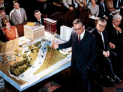
On the smallest scale, historians can also make use of architectural
plans. Just as historical maps can provide us with evidence of
cityscapes that no longer exist so architectural plans can provide
us with evidence of buildings that have been destroyed in fire and
war. (see film below)
|
|
The limitations of maps are very similar to the
limitations of
statistics. The accuracy of a map depends on the
quality of research that has gone into producing it. Maps like
statistics can be used for propaganda purposes or to fit a
nationalist agenda. Consider the richly illustrated maps of the
British Empire designed to hang in every English school classroom.
The different projections that can be used to produce a map of the
world can make Europe seem bigger or the United States at the
centre. A reliably accurate world map can even be produced to have
Australia at the top.

The most obvious weakness of maps and plans like statistics is that
there is only so much about the past that can be conveyed by a map.
A map tells us nothing of life of the people who live in the
countries illustrated. |